New Delhi: Recent satellite imagery has disclosed the magnitude of destruction inflicted by India’s military operations on May 10 at Pakistan’s Murid and Nur Khan airbases, which are among the nation’s primary facilities.
The high-resolution satellite images, both pre- and post-strike, provided by Maxar, illustrate the devastation of two large trucks, believed to be command and control vehicles, along with the demolition of a nearly 7,000 sq ft structure at Nur Khan Airbase situated in Rawalpindi.
This airbase is in close proximity to the Pakistan Army’s General Headquarters and the Strategic Plans Division, which oversees the management of the nuclear arsenal.
On May 10, India’s military executed strikes on eight Pakistani airbases, including Murid and Nur Khan, in response to Pakistani assaults on various military installations earlier that same day. Shortly after the Indian strikes, both parties reached an agreement to cease firing and military operations late in the afternoon of May 10.
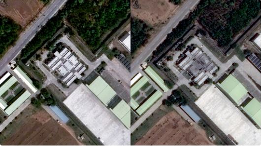
The images of Murid airbase, located in Chakwal within Pakistan’s Punjab province and approximately 150 km from the Line of Control (LoC), reveal a nearly three-meter-wide crater resulting from the strike, situated near what appears to be an underground facility, along with damage to another structure.
The underground facility is heavily fortified, indicating that the site may function as a storage area for specialized equipment or as a shelter for personnel, according to experts who have analyzed the images.
Murid airbase is vital to the operations of the Pakistan Air Force’s unmanned aerial vehicles (UAVs).